Lesotho: An Essential Guide to the Mountain Kingdom
The first sound is mechanical. Our 4×4 vehicle claws its way up a chain of switchbacks carved into the escarpment, loose gravel cracking under the tires, the steering column humming like it’s wired straight into the rock. Then the air shifts. Thinner. Sharper. It hits the back of your throat and makes you aware of each breath. Crossing from the foothills of the Drakensberg into Lesotho doesn’t feel like a border post stamped in ink. It feels like a vertical migration—an ascent into a country defined by altitude instead of ocean or bushveld.
Travel to Lesotho overview articles love the phrase “Kingdom in the Sky.” It sounds theatrical. It also happens to be geologically precise. Lesotho is the only sovereign state entirely above 1,000 meters, with vast stretches rising far beyond 2,000. Maseru sits lower along the western fringe, but once you drive east, the plateau opens and the wind starts speaking in a different register. You don’t drift into Lesotho geography. You earn it.
Height alone doesn’t make this place compelling. It’s the friction between terrain and identity. Basotho nation history is welded to slope, valley, ridgeline. The mountains aren’t decorative. They function as infrastructure, as defensive wall, as living archive.
Heritage Overview
The History and The Legends
You can’t talk about Lesotho without talking about displacement. The Lifaqane—folded into the broader Mfecane disruptions—triggered migrations that tore through Southern Africa. Cattle economies buckled. Alliances dissolved. Communities reassembled under pressure that would have snapped weaker systems.
In that fracture zone, Moshoeshoe I did something rare. He built instead of merely defended. He pulled fragmented clans into a Basotho identity rooted in elevation and maneuverability. Thaba Bosiu, the sandstone plateau near modern Maseru, became his nerve center. The choice wasn’t poetic. It was tactical. Steep approaches. Narrow access corridors. Sightlines stretching for kilometers. Anyone advancing uphill did so exposed.

The mountains didn’t make the Basotho invincible. They altered the arithmetic. From Thaba Bosiu, Moshoeshoe I negotiated with British authorities and navigated Boer expansion without surrendering the high ground—politically or physically. Geography became leverage. When you stand there, wind pushing hard against your jacket, you don’t read history. You feel its geometry.
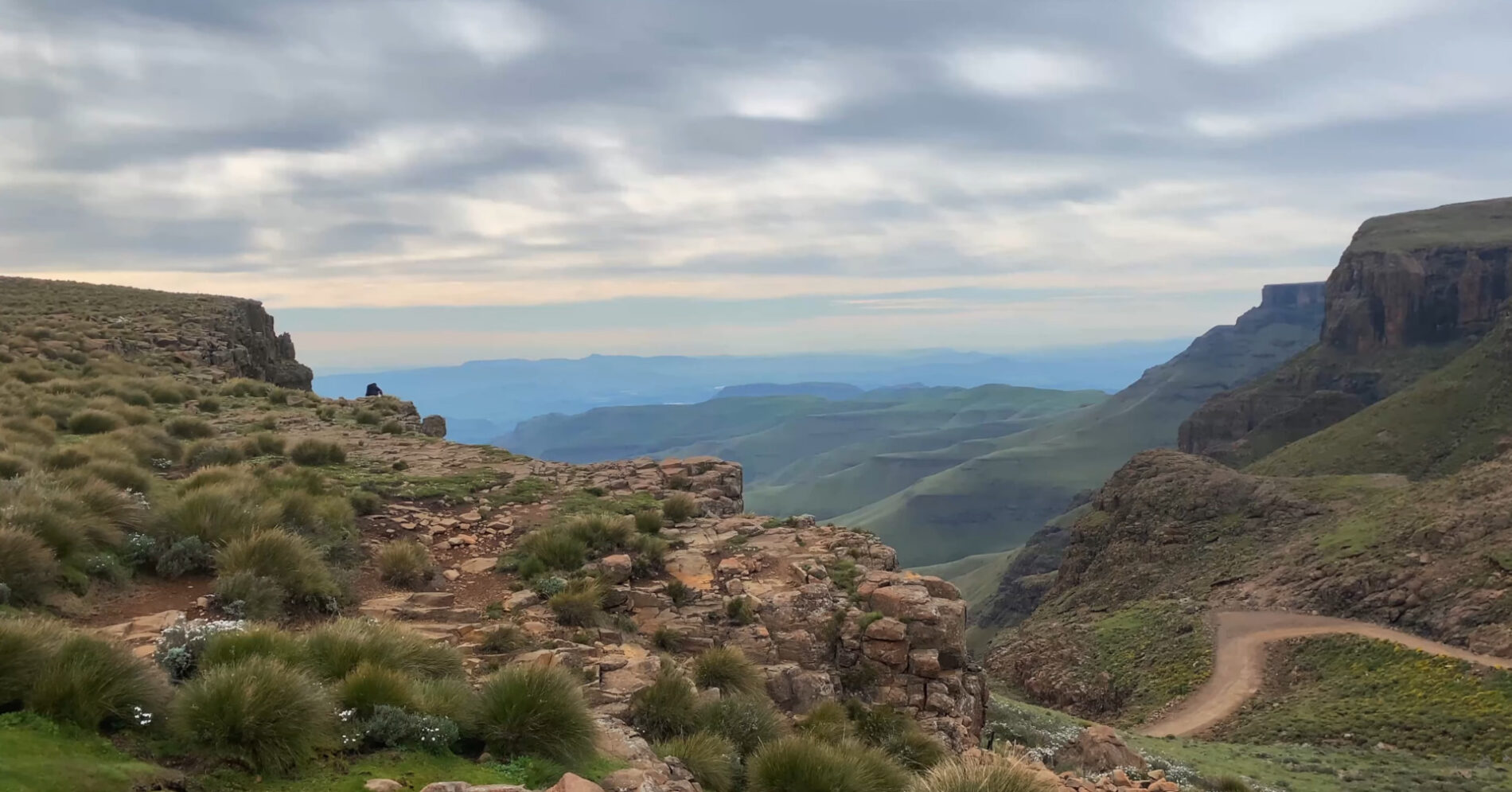
What struck me at the border into Lesotho wasn’t ceremony. It was terrain asserting authorship. Crest the escarpment and the land opens into high grasslands split by river gorges cut deep into basalt. The Drakensberg stops framing the horizon and dissolves into a broader plateau system. History becomes topographical.
And the stories persist. Raids redirected by altitude. Rival groups folded into alliances through negotiation instead of eradication. A king who understood flexibility as survival. Basotho nation history isn’t folklore frozen in amber. It’s adaptive governance under environmental constraint—and that constraint is visible in every ridgeline.
Architectural & Cultural Details
Lesotho geography dictates design with no patience for aesthetics detached from climate. Rondavels—circular stone-and-mud dwellings—sit low against the wind. Rooflines stay compact, angled to shed rain and manage frost. Entrances are positioned to capture winter sun and reduce heat loss. At 2,500 meters and above, architecture becomes negotiation between insulation and what the land actually provides.
Even livestock enclosures read like environmental engineering. Cattle and sheep are positioned against slopes that break prevailing gusts. Water access shapes settlement placement more than road grids ever could. Walk deeper into rural Lesotho and you’ll see footpaths stitched along ridgelines, grazing routes repeating season after season. The land records memory.
Basotho heritage blankets deserve more than a passing mention. Thick wool. Graphic patterns. Functional insulation against alpine wind. Their colors cut sharply against muted plateau grass. These aren’t props for visitor photographs. Herders wear them daily, guiding ponies across uneven ground that would exhaust an unacclimated traveler in an hour. At dusk, wood smoke threads through villages and clings to fabric. It lingers.
Step out at a roadside viewpoint above the escarpment and the cold hits fast. Altitude recalibrates tempo. Movements slow. Speech compresses. Weather dictates routine more than clocks do. Travel to Lesotho overview pieces often miss that subtle shift in rhythm. They shouldn’t.
What to Look For When You Visit
- The tight gravel switchbacks of Sani Pass cutting through the Drakensberg
- Basotho heritage blankets functioning as insulation and identity in high-altitude wind
- Stone rondavels angled to deflect gusts and capture winter sunlight
- Livestock trails etched into highland slopes, mapping pastoral continuity
Etiquette and Responsible Tourism
Remoteness gets romanticized. The reality is practical. Rural communities operate independently of tourism cycles. Herding remains central to household income. Agriculture persists in valley pockets where soil and water cooperate—barely, sometimes.
Visitors step into working landscapes. Photography requires consent. Entering a homestead requires invitation. Greetings matter. “Lumela” in Sesotho goes further than you’d expect. If invited for tea, accept with presence, not spectacle. Sound travels easily in thin alpine air. So does attitude.
Local Etiquette Rule
Always ask before photographing individuals, homes, or livestock. If a local guide facilitates village access, tip discreetly in cash—remote highland areas often lack reliable electronic payment systems.
How to Experience This Responsibly (Tour Options)
Ideal for travelers who want political context without committing to high-altitude driving: a Maseru-based heritage circuit centered on Thaba Bosiu. You get structured interpretation, manageable road conditions, and direct engagement with Basotho state formation. Skip it if you’re chasing dramatic alpine panoramas at every turn. This route privileges narrative over spectacle.
Ideal for landscape-driven explorers craving scale: a highlands journey toward Semonkong and Maletsunyane Falls. Expect long mountain roads and a steady climb into open plateau. As our 4×4 vehicle edged along shale-lined bends, the tires grinding against loose rock, I was reminded that elevation extracts energy as efficiently as it delivers awe.

Ideal for travelers comfortable with paperwork and gradients: the ascent via Sani Pass. It links South Africa’s Drakensberg to Lesotho in a tight sequence of switchbacks and border formalities. Documentation matters. Vehicle clearance matters. Preparation matters more than bravado.
Pricing varies by structure and distance. Shared day excursions often start in the lower triple-digit USD range. Small-group highland routes sit higher. Private itineraries combining remote passes and overnight stays can run several hundred dollars per person. The cost reflects fuel burn, suspension wear, guide skill, and the mechanical strain required to move through Lesotho geography. Mountain logistics are unforgiving.
Frequently Asked Questions
Is Lesotho entirely mountainous?
Yes. Lesotho is the only country entirely above 1,000 meters elevation. Large sections of its eastern territory exceed 2,000 meters, shaping climate patterns, agricultural limits, and infrastructure decisions.
Do I need a 4×4 vehicle to explore Lesotho?
Primary routes near Maseru are accessible by standard vehicles in stable weather. Highland passes such as Sani Pass and remote plateau tracks frequently require 4×4 vehicles due to steep gradients, loose gravel surfaces, and rapid weather shifts.
What is the best season to visit Lesotho?
The dry season, generally April through September, offers clearer hiking conditions and more predictable road surfaces, though winter nights drop below freezing. The wet months bring greener highlands and stronger waterfall flow, alongside increased road challenges.
Preserving the Kingdom in the Sky
Lesotho doesn’t compete with safari-heavy neighbors or coastal resorts. It occupies its own narrative lane. Basotho culture formed under pressure—environmental, political—and the mountains remain central to that equation. Conversations around sustainable tourism and infrastructure expansion must weigh accessibility against preservation. High-altitude ecosystems fracture easily. Cultural continuity isn’t automatic.
Standing on the plateau as wind cut across open grassland, I realized something simple. Altitude sharpens perspective. The Kingdom in the Sky isn’t branding. It’s a condition—geographical, historical, human. And it demands respect.


